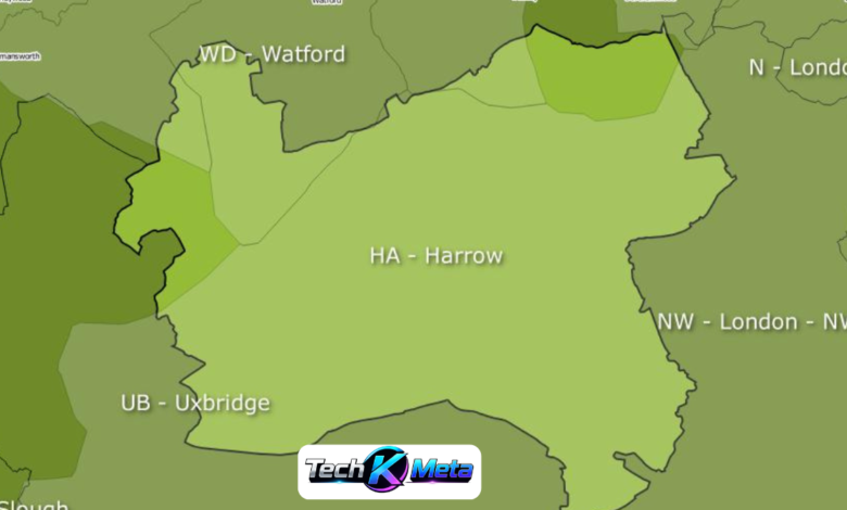
The HA postcode area is one of the useful parts of the UK postal system for identifying locations across north-west and west London and nearby parts of Hertfordshire. Covering a collection of busy towns, established residential neighbourhoods and suburban communities, it provides a practical way to organise addresses. Understanding the HA postcode area can be helpful when researching property, checking deliveries, exploring local geography or simply learning more about London’s postcode structure.
A clear HA postcode map makes this information easier to understand because it shows how individual postcode districts fit together across the wider region. The area includes districts from HA0 to HA9, with each district covering its own collection of streets and neighbourhoods. Although postcode boundaries are designed primarily for postal purposes, they can still provide a useful geographical reference when comparing locations, searching for addresses and understanding the relationship between different parts of north-west London.
What Is the HA Postcode Area?
The HA postcode area is commonly associated with Harrow and covers a substantial part of north-west London. It includes several well-known locations, including Harrow, Wembley, Ruislip, Pinner, Northwood, Stanmore and Edgware. The postcode area is divided into ten main districts, beginning with HA0 and continuing through HA9. Each district provides a more detailed way of identifying an address within the wider postal region.
Unlike administrative boundaries, postcode boundaries are created to support the efficient sorting and delivery of mail. This means that an HA postcode does not necessarily indicate a particular council area or neighbourhood in the same way that a local authority boundary does. For accurate address research, it is therefore useful to understand both the broader postcode area and the more precise district and full postcode.
HA Postcode Map and the Areas It Covers
The HA postcode map covers a diverse collection of communities. Harrow is central to the identity of the postcode area, while Wembley, Ruislip, Pinner, Northwood, Stanmore and Edgware are also important locations within the wider postal region. These places vary considerably in character, from busy urban centres and transport hubs to quieter suburban streets and residential neighbourhoods.
The geographical spread of the HA area makes postcode districts particularly useful for identifying locations. Someone searching for an address in Ruislip may encounter HA4, while an address in Pinner may use HA5. Northwood is associated with HA6, Stanmore with HA7 and Edgware with HA8. This structure allows the wider area to be broken into manageable postal sections.
HA Postcode Districts Explained
The ten principal HA postcode districts are HA0, HA1, HA2, HA3, HA4, HA5, HA6, HA7, HA8 and HA9. HA0 and HA9 are associated with Wembley, while HA1, HA2 and HA3 cover different parts of Harrow and nearby communities. HA4 is strongly connected with Ruislip, while HA5 covers Pinner and HA Postcode Map surrounding areas. HA6, HA7 and HA8 cover Northwood, Stanmore and Edgware respectively.
Each postcode district contains numerous smaller postcode sectors and individual addresses. This hierarchy means that the first part of a postcode gives a broad geographical indication, while the complete postcode identifies a much smaller delivery area. Understanding this structure is particularly valuable for people who regularly work with addresses, deliveries, property listings or local business information.
Understanding HA0, HA1 and HA2
HA0 is primarily connected with Wembley and neighbouring areas, making it an important district within the wider postal region. Wembley is a major destination in north-west London, known for its transport connections, residential communities and major attractions. The district demonstrates how postcode information can help distinguish a particular part of the wider HA area.
HA1 and HA2 are associated with different sections of Harrow and nearby neighbourhoods. HA1 includes Harrow and Harrow on the Hill, while HA2 includes areas such as South Harrow, West Harrow and surrounding communities. When using a postcode map, these districts help readers understand the broad location of an address without needing to memorise every individual street.
Understanding HA3, HA4 and HA5
HA3 includes locations around Harrow Weald, Wealdstone and Kenton, together with nearby neighbourhoods. It represents another important part of the Harrow-focused section of the postcode area. Because the district includes several local communities, a postcode can provide a useful starting point when narrowing down an unfamiliar location.
HA4 is widely associated with Ruislip and includes areas such as South Ruislip, Ruislip Manor and Ruislip Gardens. HA5 is linked with Pinner and includes surrounding areas such as Hatch End and parts of Eastcote. These districts show how the postal system separates nearby communities into distinct geographical delivery zones.
Understanding HA6, HA7, HA8 and HA9
HA6 is associated with Northwood, Northwood Hills and nearby areas, while HA7 covers Stanmore and surrounding neighbourhoods. These districts are useful for identifying locations in the northern part of the wider HA postcode area. They also demonstrate that postcode areas can extend across different local administrative boundaries.
HA8 is mainly associated with Edgware and nearby communities, while HA9 is another important Wembley district. Looking across HA6 to HA9 provides a useful picture of how the postcode area stretches across several distinctive parts of north-west London. A detailed map can make these relationships much easier to visualise.
How to Read an HA Postcode Map
Reading a postcode map becomes simple once the UK postcode hierarchy is understood. The letters HA identify the wider postcode area, while the number following them identifies the district. For example, HA1 and HA6 are different districts within the same broader area. A complete postcode then includes additional characters that identify a much more precise delivery location.
For exact address verification, a general map should not be the only source used. Royal Mail’s official Postcode and Address Finder can be used to check addresses and postcodes. This is especially important for deliveries, official correspondence, business records and property-related research where an incorrect postcode could cause confusion or delays.
HA Postcode Map for Property Searches
The HA postcode map can be particularly helpful when researching property in north-west London. Buyers and renters can use postcode districts to organise property searches and compare different areas. For example, someone interested in Harrow, Pinner or Ruislip can use the relevant postcode district as a convenient starting point for exploring homes and local neighbourhoods.
However, postcode information should only be one part of property research. A postcode cannot tell you everything about a neighbourhood, and nearby streets can have very different characteristics. Transport links, local amenities, schools, property values, council information and the condition of individual properties should all be considered before making an important housing decision.
HA Postcodes for Businesses and Deliveries
Businesses can use HA postcode information in several practical ways. Local companies may organise service areas by postcode district, while delivery businesses can use postcode information to manage routes and customer addresses. Retailers, tradespeople and other service providers may also use postcode data to understand where their customers are located.
Accurate postcode information is especially important for deliveries. Even a small mistake can make an address difficult to locate or result in a parcel being delayed. Businesses should therefore verify important customer addresses using a reliable postcode service rather than relying entirely on a general map or memory.
HA Postcode Area and Nearby Postcodes
The HA postcode area sits within the wider postcode geography of London and its surrounding regions. Nearby postcode areas include UB, NW and W, while WD is also relevant towards Hertfordshire. Understanding neighbouring postcode areas can help readers put the HA region into a broader geographical context.
It is possible for two locations that appear very close on a map to have different postcode prefixes. This happens because postal boundaries are based on operational requirements rather than simply following visible town or borough boundaries. Consequently, checking the actual postcode is more reliable than assuming a location belongs to a particular postcode area based only on its name.
Why HA Postcode Boundaries Matter
Postcode boundaries are not the same as council, electoral or neighbourhood boundaries. The HA area can cover locations connected with several local authorities, which is why postcode information should not automatically be used to determine which council provides a particular service. This distinction is important when researching council tax, planning rules, local services or other administrative matters.
The best approach is to use postcode information for postal and geographical purposes, then check official local authority information for administrative questions. Understanding this difference makes it much easier to interpret the HA postcode map accurately and avoid confusing postal geography with political or administrative geography.
Common Uses of the HA Postcode Map
There are many reasons someone might search for an HA postcode map. It can help identify an unfamiliar location, understand the position of a postcode district, compare nearby areas, research properties and organise local business information. It can also be useful for people moving to the region who want a quick overview of how different communities fit together.
Postcode information is also useful for deliveries, navigation and local research. By learning the difference between the HA postcode area, individual districts and full postcodes, readers can interpret addresses more confidently. The map therefore acts as a simple geographical reference while the complete postcode provides the greater precision needed for a particular property or delivery address.
Conclusion
The HA postcode map provides a practical overview of one of the important postal areas covering north-west and west London. With districts from HA0 to HA9, it connects a broad selection of locations, including Harrow, Wembley, Ruislip, Pinner, Northwood, Stanmore and Edgware. Understanding these districts makes it easier to interpret addresses and explore the geography of the region.
Whether you are researching property, checking a delivery, studying local geography or looking for information about a particular area, postcode knowledge can be extremely useful. The key is to remember that postcode boundaries are primarily designed for postal purposes. For exact addresses and official administrative information, always combine postcode information with reliable address and local authority sources.
Frequently Asked Questions
What is the HA postcode area?
The HA postcode area is a postal region centred around Harrow and covering parts of north-west and west London, as well as a small area of Hertfordshire.
How many HA postcode districts are there?
There are ten principal districts within the HA postcode area, ranging from HA0 through to HA9.
Which areas use HA postcodes?
HA postcodes are used across locations including Harrow, Wembley, Ruislip, Pinner, Northwood, Stanmore and Edgware.
Is HA a London postcode area?
The HA postcode area is predominantly associated with Greater London, although part of the wider area extends into Hertfordshire.
What does HA1 mean?
HA1 is a postcode district within the wider HA area and is mainly associated with Harrow and nearby locations.
Can I find an exact address using an HA postcode map?
A map can help identify the general district, but an official postcode and address search is more suitable for confirming an exact address.
Also Read: moncrief